ICATMAR’s main objective is to provide an oceanographic forecasting service tailored to the needs of society.
In Catalonia, approximately 63% of the population is concentrated in coastal counties. A significant part of our economic and socio-cultural activities are linked to the sea, such as professional fishing, maritime freight transport, nautical sports, recreational fishing, or coastal tourism. However, we often see headlines about incidents such as a fisherman who went missing at sea near Arenys de Mar a few months ago, pollution spills from cargo ships, or the massive arrival of jellyfish and other drifting organisms on beaches. To give an idea, in 2024 alone, the Maritime Rescue emergency service received over 900 alerts originating from the Catalan coast.
It is in this context that the Operational Oceanography Service of ICATMAR carries out its activities. One of its main goals is to offer oceanographic forecast services to authorities, maritime professionals, and the general public in accordance with the needs of society. In this regard, ICATMAR is currently developing capabilities to provide information that enables rapid and reliable responses in emergency situations. Additionally, it will offer tools to improve the planning of maritime activities.
Moreover, just like with weather forecasting services, developing a forecasting system of this kind requires a real-time data acquisition infrastructure (observations of sea conditions) that is stable and has good spatial coverage. In parallel, numerical models will be developed to simulate ocean circulation, integrating information from real-time data assimilation from observation instruments.
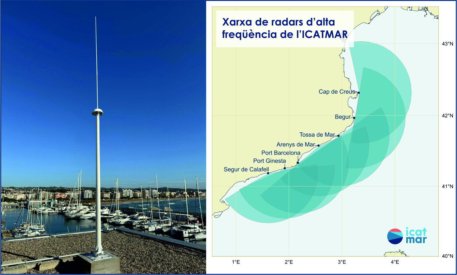
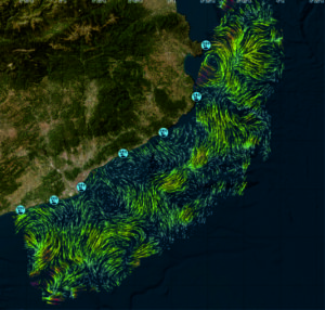
As part of the deployment of the coastal observation infrastructure in Catalonia, the final two antennas that complete ICATMAR’s High Frequency (HF) radar network were installed at the end of 2024. Today, the network consists of seven fully operational antennas strategically located along the coast: Cap de Creus, Cap sa Sal (Begur), Tossa de Mar, Arenys de Mar, Port of Barcelona, Port Ginesta, and Segur de Calafell. Thanks to this deployment, ICATMAR can monitor coastal currents with a 3 x 3 km resolution, an unprecedented level of precision in the region. As a result of these efforts, for the first time, a detailed “snapshot” of sea currents has been obtained over 200 km of Catalan coastline and up to approximately 60 km offshore.
High Frequency Coastal Radars
But how are current maps generated from the data collected by the antennas?
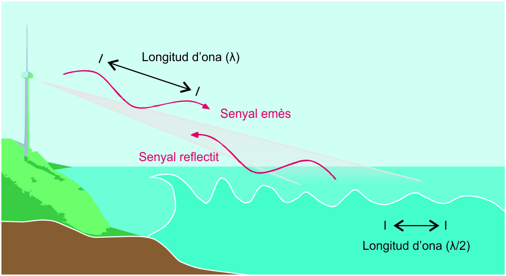
The antennas in the network combine emission and reception functions. They operate by emitting electromagnetic wave pulses at a known frequency (13.5 MHz in this case) in all directions. These waves are scattered by surface wave irregularities and reflected, so that part of the signal returns to the antenna that emitted it. Since the sea is not static but in motion due to marine currents, the reflected signal undergoes a slight frequency shift caused by the Doppler effect, similar to how our ears perceive the pitch change of an ambulance siren as it approaches and moves away. From this small variation relative to the transmitted frequency, we can calculate the velocity at which the sea is moving.
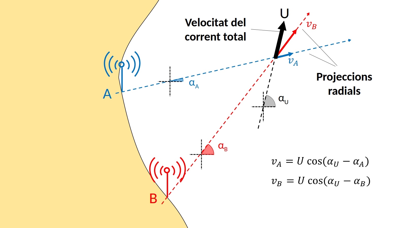
However, a single antenna can only detect the projection of the total current along its line of sight, so the information it provides is partial. To reconstruct the full current vector, at least two antennas must simultaneously measure the same area. For this reason, the deployment of ICATMAR’s HF radar network was designed to maximize the overlap of coverage areas between antennas. This allows for precise and near real-time information on coastal marine currents along the Catalan coastline.
Author: Lucía Quirós-Collazos